Without any atmosphere, the tracks and other items have remained undisturbed over the 40 years since we last set foot on the moon. “We can retrace the astronauts’ steps with greater clarity to see where they took lunar samples,” said Noah Petro, a lunar geologist at NASA’s Goddard Space Flight Center in Greenbelt, Md., who is a member of the LRO project science team.
The images show not only paths made by the lunar exploration vehicles but also the trails left in the moon’s thin soil when the astronauts exited the lunar modules and explored on foot. In the Apollo 17 image, the foot trails, including the last path made on the moon by humans, are easily distinguished from the dual tracks left by the lunar rover, which remains parked east of the lander.
“The new low-altitude Narrow Angle Camera images sharpen our view of the moon’s surface,” said Arizona State University researcher Mark Robinson, principal investigator for the Lunar Reconnaissance Orbiter Camera (LROC). “A great example is the sharpness of the rover tracks at the Apollo 17 site. In previous images the rover tracks were visible, but now they are sharp parallel lines on the surface.”
Many of the pictures from the LRO of the Apollo landing sites are included below. To see more images, including all of the pictures sent back from the LRO’s scan of the lunar surface visit the official site at: http://www.nasa.gov/lro

Apollo 11 lunar module, Eagle
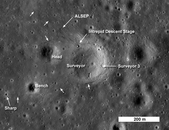
This image from LRO shows the spacecraft's first look at the Apollo 12 landing site. The Intrepid lunar module descent stage, experiment package (ALSEP) and Surveyor 3 spacecraft are all visible. Astronaut footpaths are marked with unlabeled arrows. This image is 824 meters (about 900 yards) wide. The top of the image faces North. Credit: NASA/Goddard Space Flight Center/Arizona State University
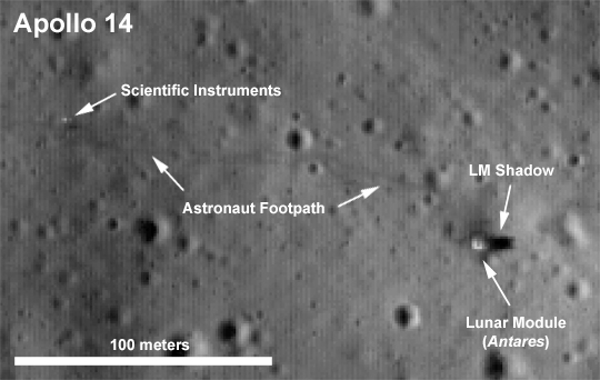
Apollo14
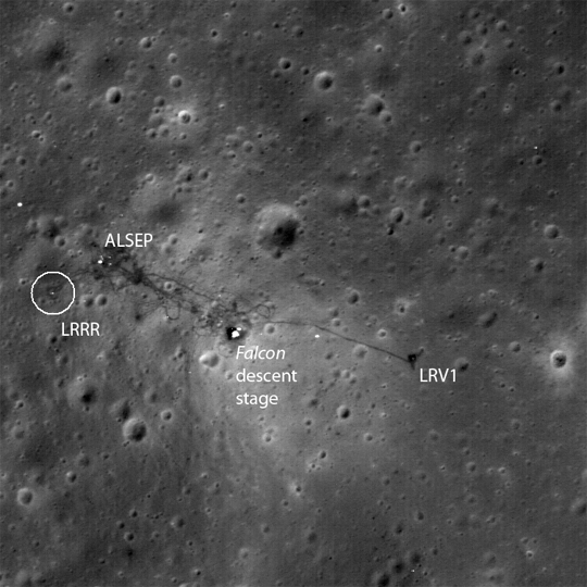
Apollo 15 lunar module, Falcon.
![Herbal Reference Substances are Key to Everyday Products <!-- AddThis Sharing Buttons above -->
<div class="addthis_toolbox addthis_default_style " addthis:url='http://newstaar.com/herbal-reference-substances-are-key-to-everyday-products/3512112/' >
<a class="addthis_button_facebook_like" fb:like:layout="button_count"></a>
<a class="addthis_button_tweet"></a>
<a class="addthis_button_pinterest_pinit"></a>
<a class="addthis_counter addthis_pill_style"></a>
</div>When it comes to quality control testing and the development of new products, Botanical Reference Materials (BRMs), also known as Herbal References are critically important. To help companies ultimately obtain all-important FDA approval, the Food and Drug Administration provides in its guidance a recommendation that […]<!-- AddThis Sharing Buttons below -->
<div class="addthis_toolbox addthis_default_style addthis_32x32_style" addthis:url='http://newstaar.com/herbal-reference-substances-are-key-to-everyday-products/3512112/' >
<a class="addthis_button_preferred_1"></a>
<a class="addthis_button_preferred_2"></a>
<a class="addthis_button_preferred_3"></a>
<a class="addthis_button_preferred_4"></a>
<a class="addthis_button_compact"></a>
<a class="addthis_counter addthis_bubble_style"></a>
</div>](http://newstaar.com/wp-content/uploads/2021/02/Achillea_millefolium_flowers-100x100.jpg)
![Quality Electrochemical Biosensors are Critical for Medical, Food and Chemical Industry <!-- AddThis Sharing Buttons above -->
<div class="addthis_toolbox addthis_default_style " addthis:url='http://newstaar.com/quality-electrochemical-biosensors-are-critical-for-medical-food-and-chemical-industry/3512086/' >
<a class="addthis_button_facebook_like" fb:like:layout="button_count"></a>
<a class="addthis_button_tweet"></a>
<a class="addthis_button_pinterest_pinit"></a>
<a class="addthis_counter addthis_pill_style"></a>
</div>A number of industries have, at their core, a need to frequent or even continuous analysis of biological media. These include the medical and pharmaceutical fields, biotech firms, and food and chemical companies. To maintain quality standards and develop new products, these industries rely heavily […]<!-- AddThis Sharing Buttons below -->
<div class="addthis_toolbox addthis_default_style addthis_32x32_style" addthis:url='http://newstaar.com/quality-electrochemical-biosensors-are-critical-for-medical-food-and-chemical-industry/3512086/' >
<a class="addthis_button_preferred_1"></a>
<a class="addthis_button_preferred_2"></a>
<a class="addthis_button_preferred_3"></a>
<a class="addthis_button_preferred_4"></a>
<a class="addthis_button_compact"></a>
<a class="addthis_counter addthis_bubble_style"></a>
</div>](http://newstaar.com/wp-content/uploads/2020/10/Electrochemical-Biosensor-100x100.jpg)
![Company Develops Industrial Mixers Well-Suited for both Fragile and Explosive Products <!-- AddThis Sharing Buttons above -->
<div class="addthis_toolbox addthis_default_style " addthis:url='http://newstaar.com/company-develops-industrial-mixers-well-suited-for-both-fragile-and-explosive-products/3512071/' >
<a class="addthis_button_facebook_like" fb:like:layout="button_count"></a>
<a class="addthis_button_tweet"></a>
<a class="addthis_button_pinterest_pinit"></a>
<a class="addthis_counter addthis_pill_style"></a>
</div>Industrial drum mixers are normally applied to blend mixes of varying viscosities such as adhesive slurries or cement. Some of these mixers have the capability of blending mixes of very different particle sizes such as fruit and ice cream, and gravel and cement slurry. The […]<!-- AddThis Sharing Buttons below -->
<div class="addthis_toolbox addthis_default_style addthis_32x32_style" addthis:url='http://newstaar.com/company-develops-industrial-mixers-well-suited-for-both-fragile-and-explosive-products/3512071/' >
<a class="addthis_button_preferred_1"></a>
<a class="addthis_button_preferred_2"></a>
<a class="addthis_button_preferred_3"></a>
<a class="addthis_button_preferred_4"></a>
<a class="addthis_button_compact"></a>
<a class="addthis_counter addthis_bubble_style"></a>
</div>](http://newstaar.com/wp-content/uploads/2020/06/bandeau-sofragir2-100x100.jpg)