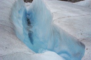
Mendenhal Glacier In Juno Alaska - credit D. Robert Curry
On Monday of this week, NASA researchers launched Operation Icebridge which is an airborne mission to study changes in the northern polar ice cap. The crews, including an international coalition, will begin the survey from their current location in Thule, Greenland.
This will be the third annual survey of the ice cap under Operation IceBridge. The mission also includes annual surveys of the southern ice sheet in Antartica beginning in October. The goal is to collect data of ice elevation on the planet as this is a key indicator for predicting and understanding climate change.
“The Canadian ice caps are notably smaller than the Greenland and
Antarctic ice sheets, but are still significant potential contributors to sea-level change in the next few decades,” said Charles Webb, deputy cryosphere program manager at NASA’s Goddard Space Flight Center in Greenbelt, Md. “They also serve as potential early-warning indicators, responding more sensitively to temperature changes than the more massive ice sheets.”
Measurements had been taken via satellite using ICESat, NASA’s Ice Cloud and land Elevation Satellite. Unfortunately, this satellite stopped functioning in 2009 and its replacement, ICESat-2, will not be operational until at least 2016. So, until that time, the agency plans to keep Operation IceBridge an annual mission.
“Each successive IceBridge campaign has broadened in scope,” said IceBridge project scientist Michael Studinger of Goddard Earth Sciences and Technology Center at the University of Maryland, Baltimore County. “This year, we have more flight hours and flight plans than ever before. We are looking forward to a busy, fruitful campaign.”
Researchers will utilize P-3B aircraft from NASA’s Wallops Flight Facility, the same type of aircraft used by the Navy to hunt for submarines. NASA’s version is outfitted with topographic mapping equipment which uses lasers to measure the changes in surface elevation. The mission will run for about 10 weeks.
![Herbal Reference Substances are Key to Everyday Products <!-- AddThis Sharing Buttons above -->
<div class="addthis_toolbox addthis_default_style " addthis:url='http://newstaar.com/herbal-reference-substances-are-key-to-everyday-products/3512112/' >
<a class="addthis_button_facebook_like" fb:like:layout="button_count"></a>
<a class="addthis_button_tweet"></a>
<a class="addthis_button_pinterest_pinit"></a>
<a class="addthis_counter addthis_pill_style"></a>
</div>When it comes to quality control testing and the development of new products, Botanical Reference Materials (BRMs), also known as Herbal References are critically important. To help companies ultimately obtain all-important FDA approval, the Food and Drug Administration provides in its guidance a recommendation that […]<!-- AddThis Sharing Buttons below -->
<div class="addthis_toolbox addthis_default_style addthis_32x32_style" addthis:url='http://newstaar.com/herbal-reference-substances-are-key-to-everyday-products/3512112/' >
<a class="addthis_button_preferred_1"></a>
<a class="addthis_button_preferred_2"></a>
<a class="addthis_button_preferred_3"></a>
<a class="addthis_button_preferred_4"></a>
<a class="addthis_button_compact"></a>
<a class="addthis_counter addthis_bubble_style"></a>
</div>](http://newstaar.com/wp-content/uploads/2021/02/Achillea_millefolium_flowers-100x100.jpg)
![Quality Electrochemical Biosensors are Critical for Medical, Food and Chemical Industry <!-- AddThis Sharing Buttons above -->
<div class="addthis_toolbox addthis_default_style " addthis:url='http://newstaar.com/quality-electrochemical-biosensors-are-critical-for-medical-food-and-chemical-industry/3512086/' >
<a class="addthis_button_facebook_like" fb:like:layout="button_count"></a>
<a class="addthis_button_tweet"></a>
<a class="addthis_button_pinterest_pinit"></a>
<a class="addthis_counter addthis_pill_style"></a>
</div>A number of industries have, at their core, a need to frequent or even continuous analysis of biological media. These include the medical and pharmaceutical fields, biotech firms, and food and chemical companies. To maintain quality standards and develop new products, these industries rely heavily […]<!-- AddThis Sharing Buttons below -->
<div class="addthis_toolbox addthis_default_style addthis_32x32_style" addthis:url='http://newstaar.com/quality-electrochemical-biosensors-are-critical-for-medical-food-and-chemical-industry/3512086/' >
<a class="addthis_button_preferred_1"></a>
<a class="addthis_button_preferred_2"></a>
<a class="addthis_button_preferred_3"></a>
<a class="addthis_button_preferred_4"></a>
<a class="addthis_button_compact"></a>
<a class="addthis_counter addthis_bubble_style"></a>
</div>](http://newstaar.com/wp-content/uploads/2020/10/Electrochemical-Biosensor-100x100.jpg)
![Company Develops Industrial Mixers Well-Suited for both Fragile and Explosive Products <!-- AddThis Sharing Buttons above -->
<div class="addthis_toolbox addthis_default_style " addthis:url='http://newstaar.com/company-develops-industrial-mixers-well-suited-for-both-fragile-and-explosive-products/3512071/' >
<a class="addthis_button_facebook_like" fb:like:layout="button_count"></a>
<a class="addthis_button_tweet"></a>
<a class="addthis_button_pinterest_pinit"></a>
<a class="addthis_counter addthis_pill_style"></a>
</div>Industrial drum mixers are normally applied to blend mixes of varying viscosities such as adhesive slurries or cement. Some of these mixers have the capability of blending mixes of very different particle sizes such as fruit and ice cream, and gravel and cement slurry. The […]<!-- AddThis Sharing Buttons below -->
<div class="addthis_toolbox addthis_default_style addthis_32x32_style" addthis:url='http://newstaar.com/company-develops-industrial-mixers-well-suited-for-both-fragile-and-explosive-products/3512071/' >
<a class="addthis_button_preferred_1"></a>
<a class="addthis_button_preferred_2"></a>
<a class="addthis_button_preferred_3"></a>
<a class="addthis_button_preferred_4"></a>
<a class="addthis_button_compact"></a>
<a class="addthis_counter addthis_bubble_style"></a>
</div>](http://newstaar.com/wp-content/uploads/2020/06/bandeau-sofragir2-100x100.jpg)